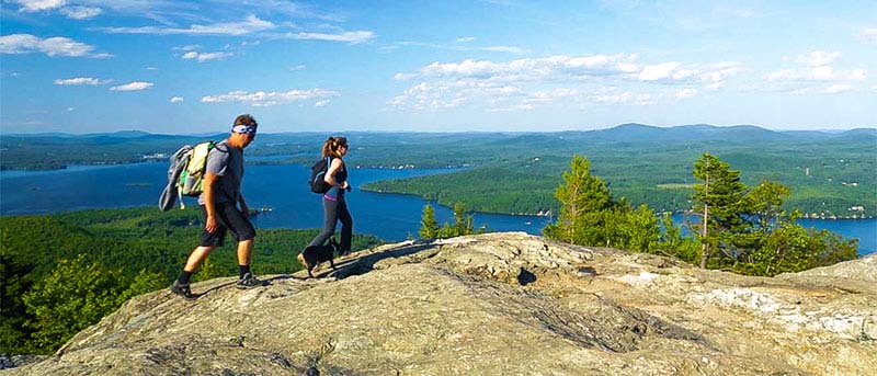
The Belknap Range Conservation Coalition (BRCC) led a guided sunset hike on Piper Mountain, Gilford NH, on June 16, 2019. BRCC members Bev Divaio and Dan Tinkham met hikers at the parking lot at the top of Belknap Carriage Road. Piper Mountain has an elevation of 2044 feet and the trail is .9 miles long. The summit is rocky and flat with great vistas west and east. We enjoyed a nice evening watching the light fade in the west amongst broken clouds. We also played a questions game about the range with prizes sponsored by TD Bank in Gilford and Bolduc Park in Laconia, followed by an explanation of who owns Piper, and what the BRCC is all about. To see the 26 questions and answers, Read More below.
1. Can you name 12 mountains in the Belknap Mountain range?
ROWE: 1680 ft. , GUNSTOCK 2245 ft. , BELKNAP 2382 ft. , PIPER 2044 ft., WHITEFACE 1664 ft., MACK 1945 ft., KLEM 2001 ft., RAND 1883 ft., ANNA 1670 ft., QUARRY W. 1894 ft., STRAIGHTBACK S. 1890 ft., MAJOR 1786 ft. Also Suncook 1851 ft., East Quarry 1890 ft., North Straightback 1910 ft., and Swett 1535 ft.
2. What Boy Scout Camp is located in the Belknap Range?
Griswold Scout Reservation Hidden Valley or Camp Bell
3. On the side of which peak will you find the remains of an 1827 iron mine?
Above the intersection of Hoyt and Belknap Mountain Roads on the west side of Gunstock about 300 feet below the summit. Back side of the top of the Panorama Lift
4. What two mountains have ski trails on them?
Gunstock and Rowe
5. Name five edible foods growing in the Belknap range?
Black berries, strawberries, raspberries, gooseberries, edible mushrooms, blue berries
6. Where can you see the remains of a collapsed caldera?
A rough circle stretching around most of the range and out to Diamond, Rattlesnake, Ship, and Moose Islands.
7. Where can you find the remains of the first rope tow in the Belknaps?
Back side of Gunstock above the Muehlke Tree farm (320 Belknap Mountain Road)
8. What is the tower on Belknap Mountain used for?
Fire lookout in the dry summer months (Red Flag Days)
9. Name five flowers that could be found in the Belknap Range.
Accept a huge number of answers
10. Which mountain in this range is hiked the most?
Major - Estimated to be over 80,000 per year!
11. Where can you find the remains of an airplane crash where one person died in 1973?
Belknap - on the east side below the fire tower
12. Where can you find the remains of a Quarrying operation?
West Quarry
13. Gunstock Mountain Resort is part of what Recreation Area?
Belknap Recreation Area
14. Who built the main lodge at Gunstock Mountain Resort?
Gunstock began as a project of the WPA - Works Progress Administration during the Great Depression in the 1930's
15. Which Belknap mountain range mountain is the highest?
Belknap at 2382 ft then Gunstock at 2245 ft ,Piper at 2044 ft, Mt. Klem at 2001 ft., Mt. Mack at 1945 ft, North Straightback at 1910 ft Major at 1786 ft, Whiteface at 1644 , Rowe at 1690 ft
16. Which peaks have little or no view?
Anna and Rand
17. Name ten mammals that could be seen in the Belknap Range.
Weasels, flying squirrel, red and gray squirrels, bats, chipmunks, otter, moose, fox, porcupine woodchuck, beaver, raccoon, muskrat, rabbits, snowshoe hare, raccoon, coyote, bobcat
18. Which trail in the range is the most hiked?
Blue (main) trail on Mt Major
19. What two hiking badges are available for hiking the Belknaps?
A badge for climbing 12 of the peaks is obtainable through Belknap County Sportsman's Association. The redlining patch is also available through the Belknap Range Trail Tenders (BRATTS).
20. What group of volunteers is very active in maintaining and upgrading the hiking trails in the Belknaps?
Belknap Range Trail Tenders (BRATTS)
21. Who was the Belknap Range and Belknap Mountain named after?
Jeremy Belknap, born 6/4/1744 and died 6/20/ 1798. Dr Jeremy Belknap requested Paul Revere write an account of the events of April 18-19, 1775 and his famous ride to give the alarm that the British were headed to Lexington and Concord. He published the first history of New Hampshire.
22. Name three mountain ranges at least partially visible from Piper Mountain?
Ossipee, Presidential, and Sandwich ranges
23. Name 8 peaks visible from Piper.
Lots, including Mount Monadnock in Jaffrey NH
24. Who created the original trail map and lots of the trails in the Belknap Range?
Dave Roberts, a founding member and director of BRCC, passed away on March 29, 2017. An avid hiker and mountain climber, Dave was also involved with the Lakes Region Conservation Trust and the Society for the Protection of New Hampshire Forests. Dave spent decades exploring the Belknap Range, marking existing trails, blazing new trails, and marking the location of numerous natural and historic features. Using early GPS technology, Dave generated the first hiking trail maps of the Range. Current Belknap Range trail maps are basically updates of Dave's original maps. There is a trail from the parking lot on Reed Road to Quarry Mountain named in his honor.
25. Where in the range were cattle pastured for more than 100 years?
Jail Pasture, where cattle from Gilmanton, Belmont and as far away as Barnstead were walked and then driven to pasture for the summer. It is bounded by Piper, Belknap, and Suncook Mountains.
26. Which mountain has the remains of a stone hut built in the 1920's so that hikers could take shelter?
Mt Major - Mr. Pippen's Hut- George Phippen of Alton built the hut in 1927. The hut's roof blew off that winter and can still can be found in the woods. Mr. Phippen gave the land up for taxes to the Town of Alton. The Town of Alton subsequently gave it to the state of NH.